
-February 10,2019-
UPDATES: NWS Hanford says Wed and Wed night will see snow level at 8000 to 9000 feet with rain below that. They say there will be 1 to 3 inches of rain below that level. By Thursday temps will chill and the snow level will fall to 5500 ft.
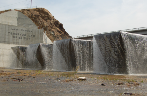
The Army Corp of Engineers has been releasing water from Lake Kaweah’s Terminus Dam for the past 2 weeks in preparation for a possible atmospheric river storm event hitting California later this week. With heavy Sierra snowpack this winter a big but warm”pineapple express” storm could bring down a torrent of runoff early in the season prompting this cautionary move by the Corp.
Kaweah Delta Water Conservation District General Manager Mark Larsen says “the Army Corps of Engineers who operates Lake Kaweah for flood control keeps the lake at a low level to allow it to handle heavy runoff due to big storm events. Recent storms brought the lake level too high for that management and the Corps required a flood release. We started that release January 28 and depending on this weekend storms and their contribution to lake inflows, we anticipate shutting off in the next week or two. It’s too soon to call.”
Through todays date (Sunday) water level at the dam has been reduced by around 13,000 acre feet- water released down the Kaweah River. The water level a the dam has gone down from around 38,000 acre feet in late January to 25,000 acr/ ft. The dam can hold 185,600 acre/ft.
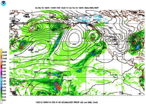
Storms in the past week have been extremely cold dropping down from the Gulf of Alaska and building the snowpack. Forecasters expects several days of wet weather Wed through Sunday but with tracts coming from both the So Pacific and from the north the temperatures as they hit central California are unclear. Forecast models show how a fire hose effect targeting the midstate Friday ( see forecast map).
Right now Sierra snow is abundant with China Peak ski resort near Huntington Lake reporting. they have received 16 feet of snow in the past 7 days as of Feb 10 on their website.
News reports suggest uncertainty going forward.
“Steve Anderson, a forecaster with the National Weather Service in Monterey, said Friday that for now, it looks like the storm seems to be headed roughly for the Santa Barbara area. Depending on the size of the storm, in that location it could cause rain in the Bay Area or, if it moved further north, rougher conditions.
“If it shifts just 50 or 100 miles north — which is almost nothing on the global scale — we could get heavy rain here, or if it shifts further south we could get nothing,” Anderson said. “We’re keeping an eye on it.”
Memories of the flooding in 2017, when atmospheric river storms in February wrecked the spillway at Oroville Dam in Butte County, are still fresh. In 1997, warm rain storms on a large Sierra snowpack caused significant flooding in Yosemite National Park and other parts of the state.
“The main problem if it does come to pass is that there is the potential for major flooding issues,” said Daniel Swain, a climate scientist at UCLA who closely monitors atmospheric rivers. “It’s a big if, but this is one of the few times recently we have had an above-average snow pack. This storm could cause some really big problems. But it is a big if.”
On Friday, the statewide Sierra Nevada snowpack was 123 percent of its historical average, and 135 percent in the Southern Sierra. Storms this weekend are expected to bring up to 3 feet of new snow.”
Familiar pattern
Three Rivers author John Austin tells the story about Kaweah floods in detail in his book Floods and Droughts in the Tulare Lake Basin.
“Heavy winter rainstorms. This is the most common cause of major flooding events. It results from heavy, relatively warm rains during November–February. Writing in 1900, John Muir described this type of flood quite well:
The Sierra Rivers are flooded every spring by the melting of the snow as regularly as the famous old Nile….Strange to say, the greatest floods occur in winter, when one would suppose all the wild waters would be muffled and chained in frost and snow…But at rare intervals warm rains and warm winds invade the mountains and push back the snow line from 2000 feet to 8000, or even higher, and then come the big floods.
When weather conditions are right, the Southern Sierra can wring amazing amounts of water out of passing storms. Precipitation events producing 10 to 20 (or many more) inches of water equivalent are possible in the region. When such superstorms are unusually warm — and particularly if they drop heavy rain on an existing snowpack and melt much of it — our main rivers can rise to peak flows well in excess of 50,000 cfs. Such extreme events have occurred infrequently in historic times. Some of the more impressive winter rain- floods occurred in 1861–62, 1867, 1955–56, 1966, 1969, 1982–83, and 1997.”