-December 14,2023-
Civil Engineering Online
Coastal desalination facilities have long been viewed by some as a way for California to solve its water woes, but such technology has sparked significant controversy over the years because of its high costs, environmental impacts, and intensive energy requirements.
However, new rapidly deployable technologies that aim to treat seawater in the ocean and then pump it onshore are undergoing testing in the Golden State.
Such offshore approaches offer potential solutions to address California’s critical water shortages while reducing the downsides of traditional onshore desalination.
Driven by drought
The Las Virgenes Municipal Water District is in Southern California, but the drinking water it provides to more than 75,000 residents in the affluent cities of Agoura Hills, Calabasas, Hidden Hills, Westlake Village, and unincorporated areas of western Los Angeles County originates in Northern California.
That water is collected and conveyed southward to the LVMWD and numerous other Southern California water providers by the State Water Project, the massive water storage and delivery system owned and operated by the California Department of Water Resources.
 “We’re 100% reliant on imported water from the State Water Project,” says Michael McNutt, the public affairs and communications manager for the LVMWD. This reliance on a single source is becoming riskier due to the globe’s changing climate. “One of the issues that we’re seeing is that climate change impacts are creating erratic weather patterns, where we can no longer rely on a reliable water supply every winter coming from the Northern Sierras,” McNutt says.
In fact, drought conditions in early 2022 prompted the LVMWD to take drastic action to ensure it maintained adequate water supplies. The district installed flow restrictors on the water meters of customers who refused to comply with water conservation requirements.
“We were the only water agency in the state that had a flow restriction program,” McNutt says. “The reason for that is because we didn’t know, at one point in time, if we were going to have enough water for people to use inside (their homes), let alone for outdoor irrigation purposes,” he says. “We were backed into a corner. We had to figure out a way to curb water usage because quite literally every drop counted.”
Fortunately, drought conditions lifted in 2023 throughout California following a series of massive storms. But the LVMWD remains vigilant in its quest to diversify its water supplies.
For example, the district has partnered with the Triunfo Water and Sanitation District to develop the Pure Water Project, an advanced wastewater reclamation facility that will provide purified water for indirect potable reuse. The agencies are operating a demonstration facility to pilot the concept.
Expected to come online in 2028, the full-scale facility will meet about 30% of the LVMWD’s water needs, McNutt says. “What that’s going to do is obviously minimize our reliance on the 100% imported water scenario,” he notes.
Deep water desalination
To be anchored to the seafloor at depths of 1,200 ft or more, OceanWell’s modular units rely on the ocean’s hydrostatic pressure to provide the feed pressure for the reverse-osmosis treatment process. (Image courtesy of OceanWell)
OceanWell modular unit. (Image courtesy of OceanWell)
The LVMWD is not stopping there, having pledged to investigate seawater desalination as another option for decreasing the district’s dependence on imported water. “We had made promises to our community and to elected officials,” McNutt says.
Although inland, the district’s service area is a mere 10 mi or so from the Pacific Ocean. But traditional coastal desalination facilities did not appeal to the LVMWD because of “our commitment to sustainability and environmental benefits,” McNutt says.
For this reason, the district turned to OceanWell, a company developing a novel approach to desalination that operates offshore in deep water to take advantage of certain properties associated with that environment.
“We’re essentially moving a desalination plant from land and putting it underwater,” says Michael Porter, Ph.D., the chief technology officer for OceanWell. “This hasn’t been done in the past, mainly because of the difficulty of working in offshore environments,” Porter says.
However, technological advancements, primarily in the field of subsea exploration for oil and natural gas, have made seafloor desalination a possibility, Porter says. “There’s been a lot of innovations in the last several decades on subsea technologies, and we are leveraging a lot of the know-how that’s coming out of those industries and applying it to our industry.”
Offshore advantages
To be anchored to the seafloor at depths of 1,200 ft or more, OceanWell’s modular units, collectively known as a “water farm,” desalinate seawater by means of reverse-osmosis membranes. Because they rely on the ocean’s hydrostatic pressure to provide the feed pressure for the RO process, the units are expected to conduct desalination using as much as 40% less energy than that of traditional onshore RO facilities, Porter says.
After passing through the RO membranes, the treated water is pumped to shore through a pipeline. Meanwhile, the reject stream from the RO process discharges through an outfall at the top of the unit.
Because OceanWell’s treatment units require much less energy than traditional desalination facilities, “we can operate at very low recovery ratios,” Porter says. As a result, the salinity of the discharged brine is “going to be a lot less salty in a low-recovery system than an onshore high-recovery system,” he notes.
For example, onshore desalination plants typically produce brine that is twice as salty as the surrounding ambient environment into which they discharge, Porter says. “In our case, we can produce brine as low as 5% or 10% above ambient (salinity),” he notes. “It’s an order of magnitude lower salinity, and in some jurisdictions it’s not even considered brine.” Because of the low saline concentration of the discharge and the depths and currents of the subsea, brine exiting the unit returns to ambient salinity within seconds of the discharge point.
Another advantage conferred by OceanWell’s approach is its minimal effects on aquatic organisms, beginning with its deep-sea location, where little sunlight penetrates. “You don’t have photosynthesis, you don’t have a vibrant food chain, and so you don’t have as much marine life,” Porter says. The cold temperatures of the deep sea also reduce biological activity. Even so, the treatment unit includes a screening system that is designed to avoid harming marine life. “It’s a multistage mechanical filtration mechanism that allows us to gently wash out any entrained organisms,” he says.
This rendering of an OceanWell “water farm” and its onshore control station highlights the system’s smaller land requirements as compared with a traditional onshore desalination facility. (Image courtesy of OceanWell)
This rendering of an OceanWell “water farm” and its onshore control station highlights the system’s smaller land requirements as compared with a traditional onshore desalination facility. (Image courtesy of OceanWell)
Unlike traditional onshore desalination facilities, OceanWell’s system has a “very small onshore footprint” that includes a control station and any additional treatment processes required by the water customer, says Kalyn Simon, the company’s director of engagement. “That’s another advantage” of OceanWell’s system, Simon says.
Pilot test planned
In August, the LVMWD and OceanWell signed a memorandum of understanding under which the company will conduct a pilot test of its treatment technology in the district’s Las Virgenes Reservoir in Westlake Village. The company previously performed prototype testing of its system at the U.S. Navy’s Deep Ocean Simulation Facility at the Naval Surface Warfare Center’s Port Hueneme Division, in Port Hueneme, California.
Multiple OceanWell desalination units can be linked together and discharge to the same pipeline that conveys treated water to shore. (Image courtesy of OceanWell)
Multiple OceanWell desalination units can be linked together and discharge to the same pipeline that conveys treated water to shore. (Image courtesy of OceanWell)
Although it holds freshwater, the LVMWD’s reservoir, which is 120 ft deep at its lowest point, will provide a “good stress test” on OceanWell’s treatment system, Simon says. “The reservoir has different metals in it, it has algae, it has a lot of bacterial life in it,” she notes. “We will be doing tests on the system in a harsher environment, we believe, than the deep ocean will be for certain aspects of the system.”
Expected to begin in mid-2024, the pilot test will last at least 5-6 months and involve a treatment unit that is 4 ft in diameter and about 10 ft tall and has a treatment capacity of 8,000 gal./day. By comparison, OceanWell’s full-scale commercial unit is nearly 40 ft wide, 33 ft tall, and can treat 5 mgd, although the modular nature of the system makes it easy to adjust treatment capacities as needed.
If the pilot test succeeds, the LVMWD and OceanWell will conduct a “larger subsea at-depth demonstration project expected to produce an initial 1,000 acre-ft per year of drinking water,” according to the MOU. Following the successful completion of the demonstration project, the entities would pursue a commercial installation capable of providing up to 11,000 acre-ft/year of fresh water to the LVMWD, while also potentially helping meet the needs of other water providers in the region, according to the MOU.
OceanWell plans to test its desalination treatment module in the Las Virgenes Reservoir in Westlake Village, California. (Image courtesy of Las Virgenes Municipal Water District)
OceanWell plans to test its desalination treatment module in the Las Virgenes Reservoir in Westlake Village, California. (Image courtesy of Las Virgenes Municipal Water District)
Working with wave power
The LVMWD is not the only California agency investigating the possible use of offshore desalination technology to help meet its water needs. In July, the city of Fort Bragg — a coastal community approximately 165 mi north of San Francisco — and Oneka Technologies, a developer of wave-powered desalination buoys, announced that they had entered a partnership to develop California’s first wave-powered desalination project.
Fort Bragg obtains its drinking water from the Noyo River, a source that has proved unreliable in recent years. During summer 2021, “low river flows, combined with high-tide events, resulted in brackish water,” according to the July 23 news release from Fort Bragg and Oneka. “Fortunately, the city was able to secure emergency grant funds from the state of California to install a portable desalination unit,” the release states.
Oneka Technologies plans to test its wave-powered desalination buoy off the coast of Fort Bragg, California, in 2024. (Image courtesy of Jesus Rivero/Oneka Technologies)
Oneka Technologies plans to test its wave-powered desalination buoy off the coast of Fort Bragg, California, in 2024. (Image courtesy of Jesus Rivero/Oneka Technologies)
Under its agreement with the city, Oneka will test the use of what it calls its Iceberg-class desalination buoy offshore of Fort Bragg. Situated on the water’s surface and tethered to the ocean floor, the 16 ft by 26 ft buoy houses a seawater treatment system that can produce up to 13,200 gal./day, depending on wave height, according to Oneka’s website. The buoy is to be located 0.1 to 0.3 mi offshore in water depths between 43 and 98 ft.
Zero emissions
The oscillating motion of waves drives the treatment system. As the buoy moves down in the trough, it induces seawater to enter and pass through a 60-micron mesh strainer designed to reduce impacts to marine life. As the buoy rises with the wave, the motion pressurizes a pump, which conveys the water into a pressure-and-flow optimization system. From there, the water is forced through a self-cleaning RO membrane system that is designed to achieve a 25% recovery rate.
The resulting brine, which is 30% more saline than normal ocean conditions, is discharged into the ocean, where it is diffused by wave action and sea currents. The treated water is pumped to shore. Depending on the required volume of treated water, multiple buoys may be arranged as part of a modular system.
A key benefit of Oneka’s technology is that it “takes the ocean’s own energy to desalinate seawater, instead of having other sources of energy to feed the desalination process,” says Marie-Cécile Cléroux, the company’s coordinator for marketing and communication. “Oneka’s system is decentralized and 100% mechanical,” Cléroux says. “It does not depend on any other energy than the power of the waves and produces the freshwater to the coastline without any greenhouse gas emissions.”
For the pilot project, the buoy is planned to be deployed in 2024 for a demonstration period of 12 months. Permitting for the project is underway, Cléroux says. “We’ve already received permits for weather wave data buoys and installed them,” she notes. “These indicate the wave statistics of the site.”
Another type of buoy
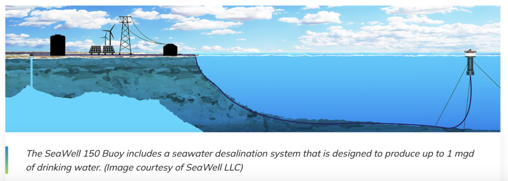
SeaWell LLC is another company developing an offshore desalination technology that operates at the water’s surface. Designed to produce up to 1 mgd, the SeaWell 150 Buoy features a 21 ft diameter top deck that connects to a narrower cylinder, which extends downward to the intake structure on the bottom of the buoy, about 40 ft below the surface. The buoy is anchored to the seafloor.
The SeaWell 150 Buoy includes a seawater desalination system that is designed to produce up to 1 mgd of drinking water. (Image courtesy of SeaWell LLC)
The SeaWell 150 Buoy includes a seawater desalination system that is designed to produce up to 1 mgd of drinking water. (Image courtesy of SeaWell LLC)
The intake is outfitted with wedge wire screens with 1 mm openings that are designed to reduce the velocity of the entering water and limit the entrainment and impingement of aquatic organisms. Before entering the RO process, water passes through a series of filters. “We are very focused on the water quality going to the membranes,” says SeaWell CEO Peter Stricker.
High-pressure pumps then push the water through the RO membranes, and the treated water is pumped to shore via a conveyance pipeline. Brine from the RO membranes that is 43-54% more saline than seawater is discharged from the buoy near the water surface, according to Stricker. Meanwhile, energy-recovery devices use the pressure of the brine stream to generate energy.
The SeaWell 150 Buoy includes a seawater desalination system that is designed to produce up to 1 mgd of drinking water. (Image courtesy of SeaWell LLC)
The SeaWell 150 Buoy includes a seawater desalination system that is designed to produce up to 1 mgd of drinking water. (Image courtesy of SeaWell LLC)
Releasing brine near the water surface offers a “great advantage” when it comes to ensuring that discharges from the buoy do not negatively affect ambient salinity levels, Stricker says. “There’s a great natural mechanism for mixing because we’re high in the water column and the highest current velocities are up there too,” he notes. “Brine is heavier than seawater, so it sinks.” Modeling conducted by SeaWell indicates that the brine “doesn’t descend very far before the salinity becomes very close to ambient seawater salinity,” Stricker says.
Treated water is conveyed to SeaWell’s onshore facility. Dubbed the “Water Station,” the post-treatment module disinfects, adjusts the pH, and remineralizes the desalinated water to meet drinking water standards and ensure compatibility with customers’ distribution systems.
‘Grand scheme’
In November, SeaWell began testing a smaller version of its buoy at the Deep Ocean Simulation Facility. The basic operational testing will last three months and potentially be extended another six months, Stricker says.
The testing is in advance of a pilot project that SeaWell plans to conduct in 2024 offshore of the Vandenberg Space Force Base in Santa Barbara. Eventually, SeaWell aims to provide drinking water to the U.S. Space Force facility, which currently relies on water sources that are prone to drought.
Ultimately, SeaWell’s “grand scheme” is to deploy its technology along all of California’s coastal counties, Stricker says. The plan is known as Water Tap and would involve strategically locating SeaWell’s Water Stations so that water agencies would be readily able to draw from the system as needed. Buoys could be rapidly added during droughts or other periods of high water demand and then removed when they are no longer necessary.
By meeting the needs of California’s coastal communities, the Water Tap plan would enable the State Water Project to concentrate its deliveries to the Central Valley and other inland areas that cannot readily access desalinated water.
“We think that’s a really beautiful, sensible idea,” Stricker says.
This article is published by Civil Engineering Online.


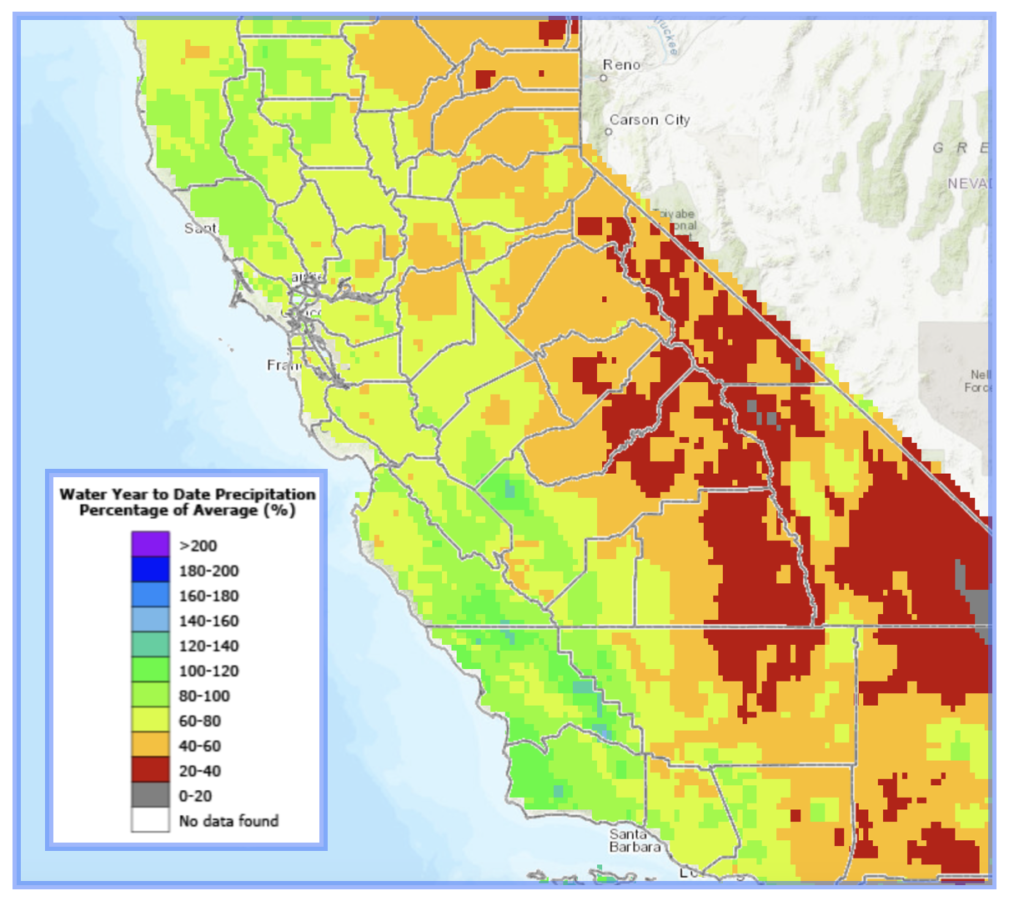 Looking at the latest statistics, the Central Coast and generally the entire coast of California have seen closer to average rainfall compared to much of the rest of the state, including the Sierra where snowpack has been slow to build.
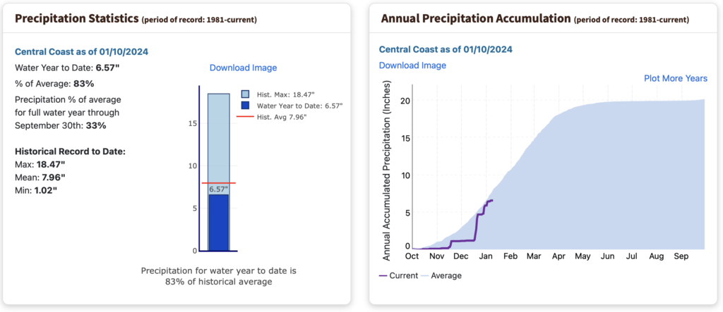 In fact the Central Coast stands at a respectable 83% of average as of January 10 says the California Department of Water Resources.Their precip map shows widespread green along the coast compared to red (20 to 40 % of average) along the Sierra crest.



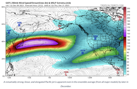
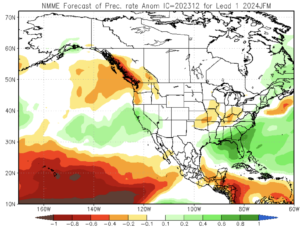

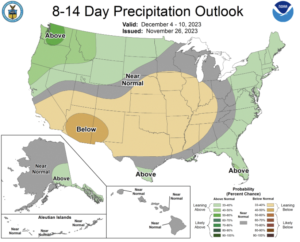
 Fed by an El Nino pattern, the model shows an Atmospheric River coming from the southwest December 6.
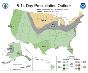 “Models suggest that the current El Niño event will further strengthen it potentially into a very strong, or a quote-unquote, ‘super’ El Niño event, within the next couple of months,” he added.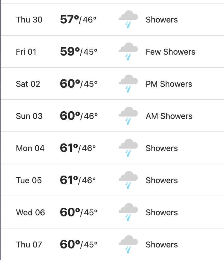

 The unemployment rate in the San Luis Obispo County was 3.6 percent in September 2023, down from a revised 3.7 percent in August 2023, and above the year-ago estimate of 2.7 percent. This compares with an unadjusted unemployment rate of 4.9 percent for California and 3.6 percent for the nation during the same period.
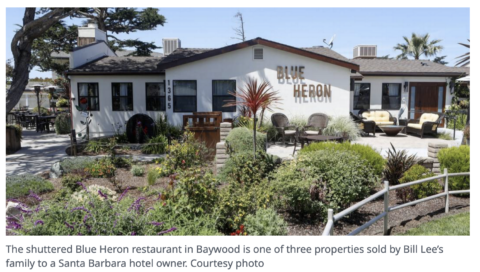 It will no longer be the Blue Heron restaurant when it reopens now that Santa Barbara hotel owner Carl Johnson of Vintage Hotels Inc has posted an application for a liquor license as of late October. Johnson bought the property along with the Back Bay Inn last year but has only recently decided to reopen the shuttered sit-down eatery along the bay.The landmark eatery closed during Covid 19 epidemic.

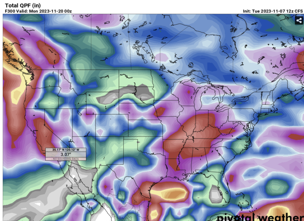

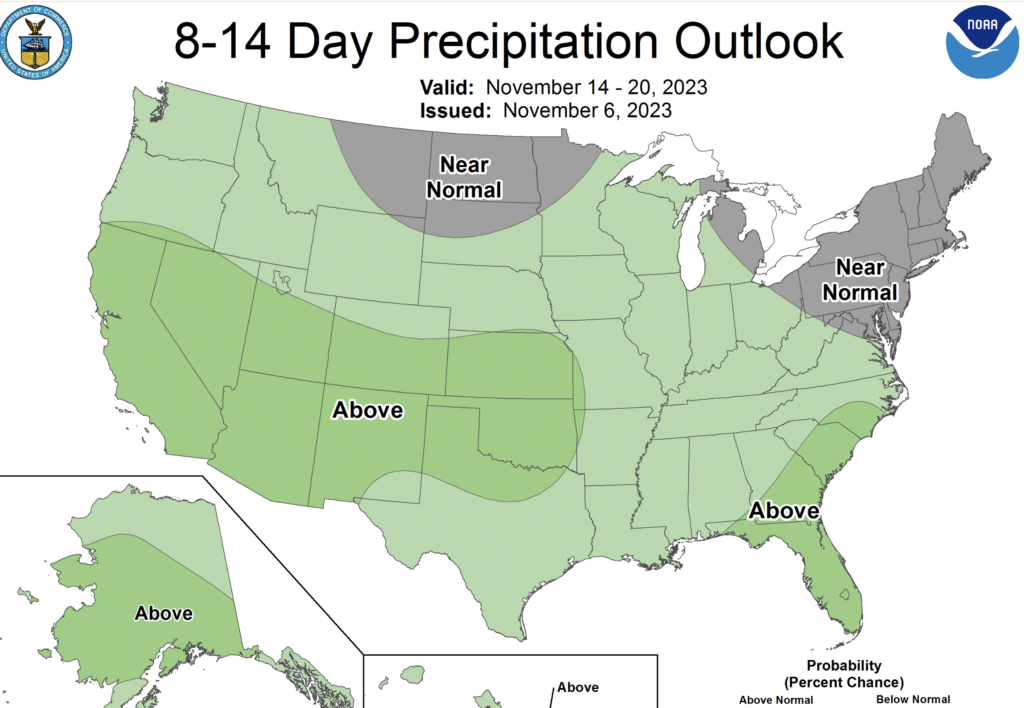


 Warmer-than-average temperatures are favored across the northern tier of the U.S. and much of the Far West.
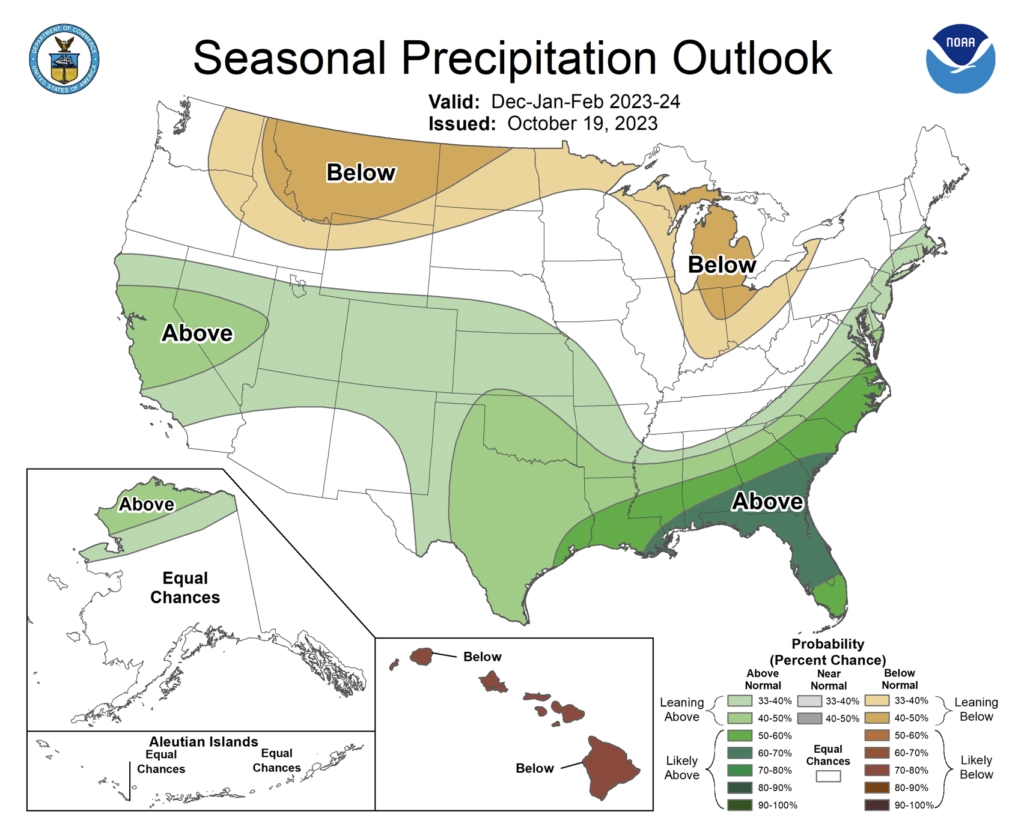 Wetter-than-average conditions are most likely in northern Alaska, some areas of the West from parts of California to the south-central Rockies, the southern Plains, Gulf Coast, Southeast and lower mid-Atlantic.