
 Tale Of Two Winters & Two Californias
It poured in Northern California in December as rainfall totals were over 200% of normal for the water year starting October 1 and going into the New Year.
Even today – three weeks later – the state DWR says the Northern California Water Index stands at 142% of normal for this date with 33 inches of precipitation so far. The agency says in an average water year (ending after April) we can expect around 50 inches in the bucket.
For the 5-station San Joaquin Valley Index – more indicative of our neck of the woods – the index is at 109% of normal for the date having already received about half the 40 inches we can expect by the end of April in a “normal “ year.
But if this football game’s first half has been full of stormy excitement – the second half – January and now likely February seem like a much different team has showed up on the field and they are a quiet and literally – cold bunch.
“February like January looks on the dry side” says Alan Fox of Fox Weather who predicted the record breaking storms in late November and December characterized by what NOAA called “ atmospheric rivers “ of tropical moisture that funneled into California. Some places along the Feather River got over 2 inches an hour one of those events.
At that time Fox saw a a wet winter ahead but changes in sea temperatures to the cool side along the equator have changed the ballgame. The El Nino pattern is gone.
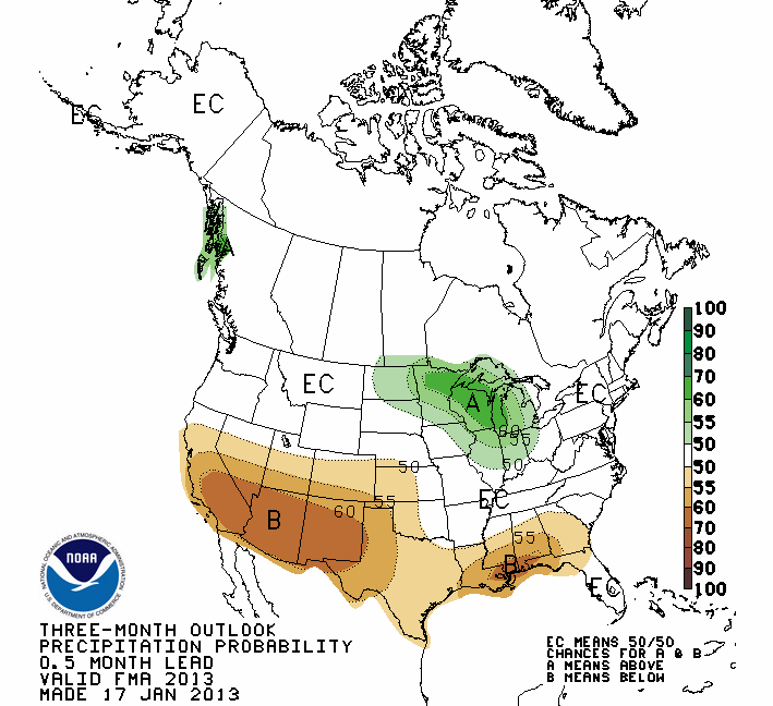
NOAA’s Climate Prediction Center has recently (Jan 17) published this three month map with big brown spot signaling dry weather over central and southern California the rest of this winter.
Not only is this bad news for central California but for drought stricken states in parts of the Midwest who desperately need rain this coming Spring to avoid another bad corn and soybean crop year
Tale Of Two Winters
After flowing freely in December the spigot seemed to be shut on “off” as of January. At the key northern reservoir at Shasta Dam that had seen 31 inches of rain in November and December – the rain gauge measured just 0.08 inches over the first 21 days of this month.
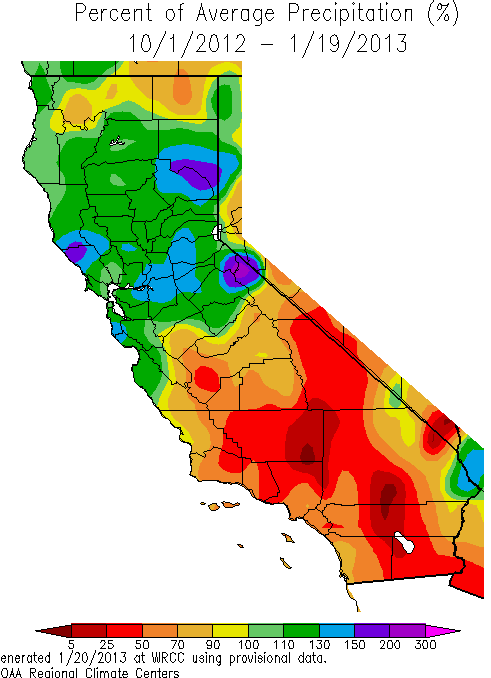
If it as a tale of two winters it is also a tale of two Californias so far this water year. This map tells the story showing the percent of average rainfall from Oct 1 through Jan 20 with part of northern California at 200%( purple) and parts of southern California at 25% of average( brown).
More dry cold weather is in the offing Fox says.
Still, forecaster Fox says he is “not giving up on February” and expects a few storms to come into the state over the month coming up.
“January 24,25 ,26 could see a small amount of rain and Feb 5,6 should see a storm that will drop snow in the Sierra “ he says.
Central Coast forecaster John Lindsey says today to expect unsettled weather for this region starting Wednesday and more promising – ”rain showers forecast on Saturday into Sunday.”
But those big rain events of December are long gone.