
Some long range weather forecasters are seeing a return of the El Nino weather pattern that was around last fall apparently providing a wet early start to winter in California. And then nada. One of the driest Springs on record.
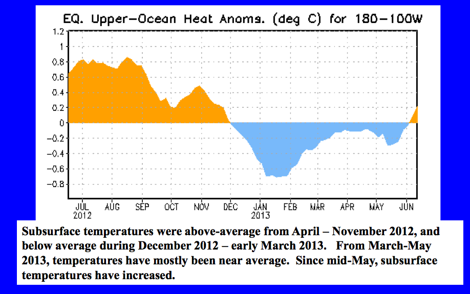
Notice how the wet weather stopped here in early January just as El Nino lost steam forecaster Alan Fox says.
Now he see a possible come back.
“We are currently seeing a weak, cold La Niña condition (colder than normal sea surface) off the coast of Peru. About mid-summer (late July), weak El Niño conditions are expected to begin, and this is expected to lead to an increase in El Niño conditions through fall and winter months and into the spring months of 2014.”
Agreeing with Fox is Scripps experimental model who is also forecasting warm (El Nino) conditions for late 2013 and early 2014 heating up water enough to perhaps wet our whistles and rest of this bone dry state.
Groundwater Pumping
After several dry years that would be good news indeed.Central Valley water district mgr water Don Mills says the Sierra will generate only a 34% runoff this year compared to 40% last year.
“We can’t depend on northern California- we need to capture more of our own runoff and not send it out to sea”
Mills expects another year of groundwater pumping will yield record low water levels and worries that “unless Central Valley interests move to manage groundwater, the state will.”
“I see in the future if you want to drill a new well you will have to prove a sustainable water supply.That will be an unpopular discussion”
Mills says he has heard spot water sales on the Westside is going for $1200 an acre/ft,” if you can find it.”
Summer Storm?
Meanwhile some relief from the summer dryness is in order over multiple days next week.
Fox says sees a strong weather pattern laying down several inches of rain through the Feather River Basin and south to I-80.
Indeed the NWS is now looking for some records to be broken.
Here is their report this week.
MODELS CONTINUING TO SHOW A TRANSITION TO A WETTER AND COOLER WEATHER PATTERN IN THE EXTENDED FORECAST PERIOD.
SHORT WAVE CURRENTLY ROUNDING THE BASE OF THE UPPER LOW IN THE GOA IS FORECAST TO DEEPEN AND MOVE ACROSS INTERIOR NORCAL SUNDAY. GFS/NAM TRENDING DEEPER WITH THIS WAVE AND SHOW SOME LIGHT QPF OVER PORTIONS OF INTERIOR NORCAL…MAINLY NORTH OF I-80.
UNSEASONABLY LARGE AND DEEP LOW PRESSURE SYSTEM MOVES INTO THE EPAC MONDAY WITH 130+ KT POLAR JET TAKING AIM AT NORCAL. THE SYSTEM HAS ENTRAINED TROPICAL MOISTURE FROM THE WESTERN PACIFIC AND ATMOSPHERIC RIVER SETS UP OVER NORCAL WITH PWAT IN EXCESS OF 1.5 INCHES. STRONG ISENTROPIC LIFT COMBINED WITH +5 ANOMALOUS PW PLUME WILL RESULT IN SEASONABLY SIGNIFICANT PRECIPITATION OVER PORTIONS OF NORCAL. MODELS CONTINUE TO SHOW RUN TO RUN INCONSISTENCIES WITH TIMING AND AMOUNT OF QPF BUT HAVE TRENDED WETTER AND SPREAD PRECIP FARTHER SOUTH. POTENTIAL FOR ALL OF THE CWA TO SEE PRECIP MON/TUE WITH DAILY RECORD AMOUNTS POSSIBLE…MAINLY NORTH OF I-80.
MODELS DECREASE PRECIP AND LIFT IT NORTHWARD WEDNESDAY THEN DRY AND WARMER THURSDAY INTO THE WEEKEND AS HIGH PRESSURE FROM THE DESERT SW BUILDS TOWARDS NORCAL.