
Not only are we all not drinking enough beer and wine any more, the temperature outside is hotter than it should be.All you climate change skeptics pay attention
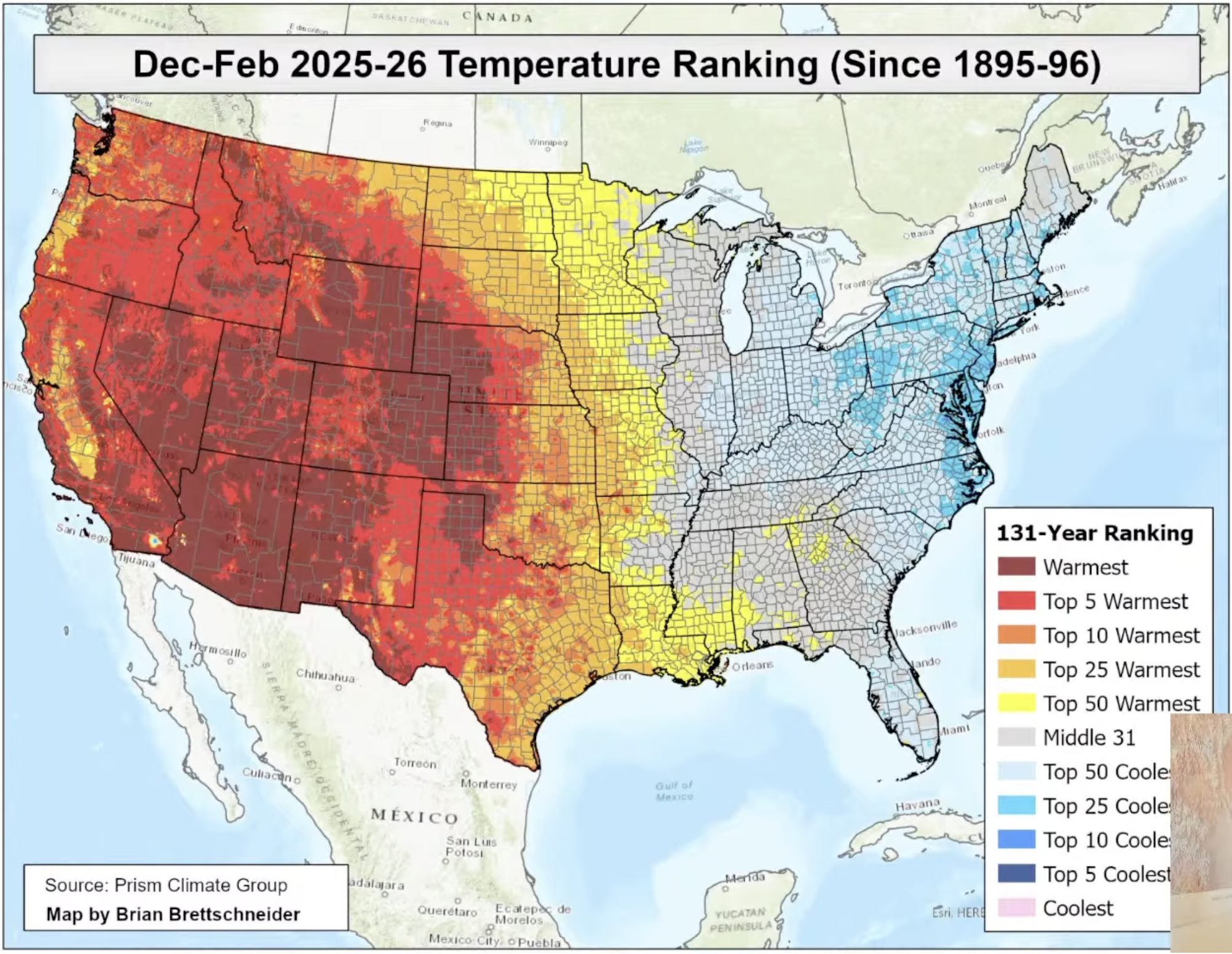
Historically warm Western US contrasted with cooler East Coast this winter
With the exception of the southern San Joaquin Valley, this winter was the warmest on record by far since 1895 across most of the Western US, says climate scientist with UC Agriculture and Natural Resources, Dr Daniel Swain. The map above shows the latest 3-month winter temps (Dec-Feb) that are as much as 10 degrees above the average – shown in dark red on this map. In a podcast earlier this month Swain emphasizes “what a very big deal this is” with all-time record heat covering most of 10 western states.
The dark red includes many parts of California – SoCal, the Central Coast, most of the Sierra and the desert areas. In square miles the largest impacted area is across much of the Mountain West including the all important Colorado River basin across Colorado,Utah and Arizona. Note that it extends east into parts of the Midwest and the Panhandle as well. Further east, cooler temps were seen including very cold events in parts of the East Coast that made headlines while little notice of the western state’s historic heat was made.
The Central San Joaquin Valley is an exception not because it wasn’t warm this winter- it was – but because a dense blanket of Tule fog kept daytime temperatures cool below the fog. But at night, Swain says the weather was warmer than usual, typically not falling below the 40s. Farm advisors say this year’s Tule fog helped raise the number of chill hours for some tree crops in the Valley helping to spur a normal bloom.But the warm nights may not add enough chill hour accumulation for some stone fruit.
Snowpack variation
“In the Western U.S., the snowpack is, on average, terrible,” Swain says. “It’s about as bad as it’s ever been in observed history.” Again there are exceptions including the snowpack water content in the southern Sierra that as of March 1 was 80% of average on March 6, says DWR. That said, contrast that number to the northern Sierra that is only 38% of average as of March 6.
What has people talking about is the rapid snow melt in all parts of the state in the past few weeks expected to continue due to extreme warm temperatures up and down California this month.
Case in point was that monstrous snowstorm that hit the Tahoe area with over 8 feet of snow, causing a deadly avalanche Feb 17. Now that snow has mostly melted away in a matter of days, notes Swain. Complicating this situation were the warm storms dropping rain on the snowpack instead of falling as snow. The warm winter is forecast to continue in the next few weeks coupled with more dry weather.
That’s true this week in the southern Sierra as well with average temperatures in the next few days in Grant Grove at 6500 feet hitting 60°.
Here is the March 7 forecast posted by Friant Water. “Through the weekend, temperatures are expected to be within 5 degrees of normal in the San Joaquin and Tulare Basins, within 10 degrees of normal in the Southern Sierra, near normal to 10 degrees above normal in the Sacramento Valley, Southern California, and along the Central Coast, and near normal to 20 degrees above normal in the North Coast, Northern Sierra, and northeastern portion of the State. “
This is also happening on the coast with a 93 year old temperature record broken at the Santa Maria airport where the high reached 88° surpassing a daily record of 86° set in 1932 says forecaster John Lindsey. Some desert stations in the past few days have hit 100° in winter.
Lindsey adds that the west coast warmth affected our oceans as well.”This winter has been marked by well-above-average sea surface temperatures (SST), primarily due to a lack of northwesterly winds.” He says the water is cooler this week but for “most of December, January, and February, temperatures remained around 60 degrees, about 5 degrees above normal.”
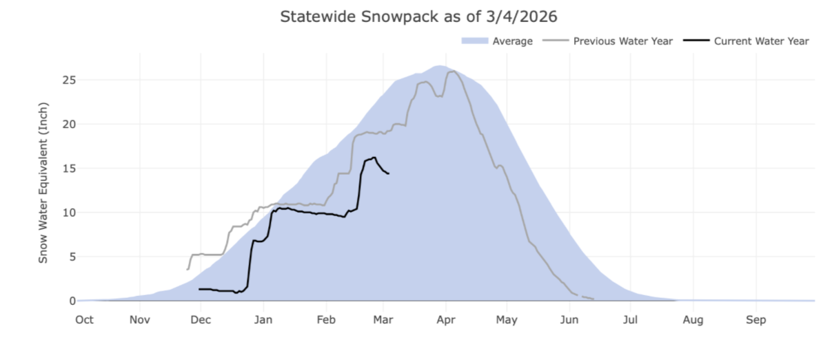
Here is the March 4 Sierra snowpack chart – note the meltdown recently.
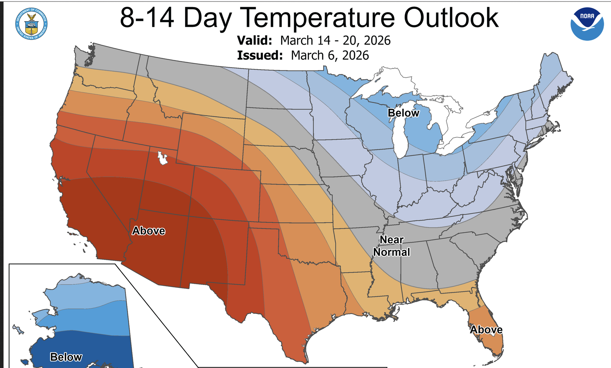
NWS Hanford says this warm/dry pattern is likely to continue through the next two weeks as the Climate Prediction Center maintains above normal temperatures and below normal precipitation through Day 14.
But this winter story has also been affected by rainfall variation as can be seen in this other map. Some parts of the western US were affected by record low rainfall – some places under 25% of normal shown brown on the map.
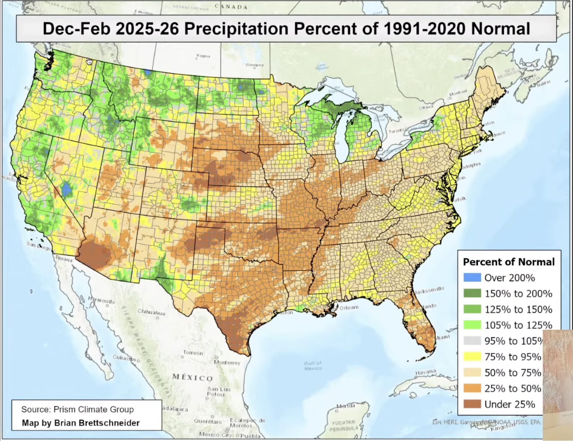
Swain adds that in California the Southern Central Valley and Central Coast saw normal or even above normal rainfall over the 3 month period.Much of the Colorado River Basin seems to be hard hit by a combination of record heat and low rainfall that will surely impact the water supplies of cities in the western US, including Los Angeles, Tucson, Las Vegas, and Phoenix later this year. Of course it will hit the farming community hard as well as all plans for all those water-hungry data centers in the Southwest.
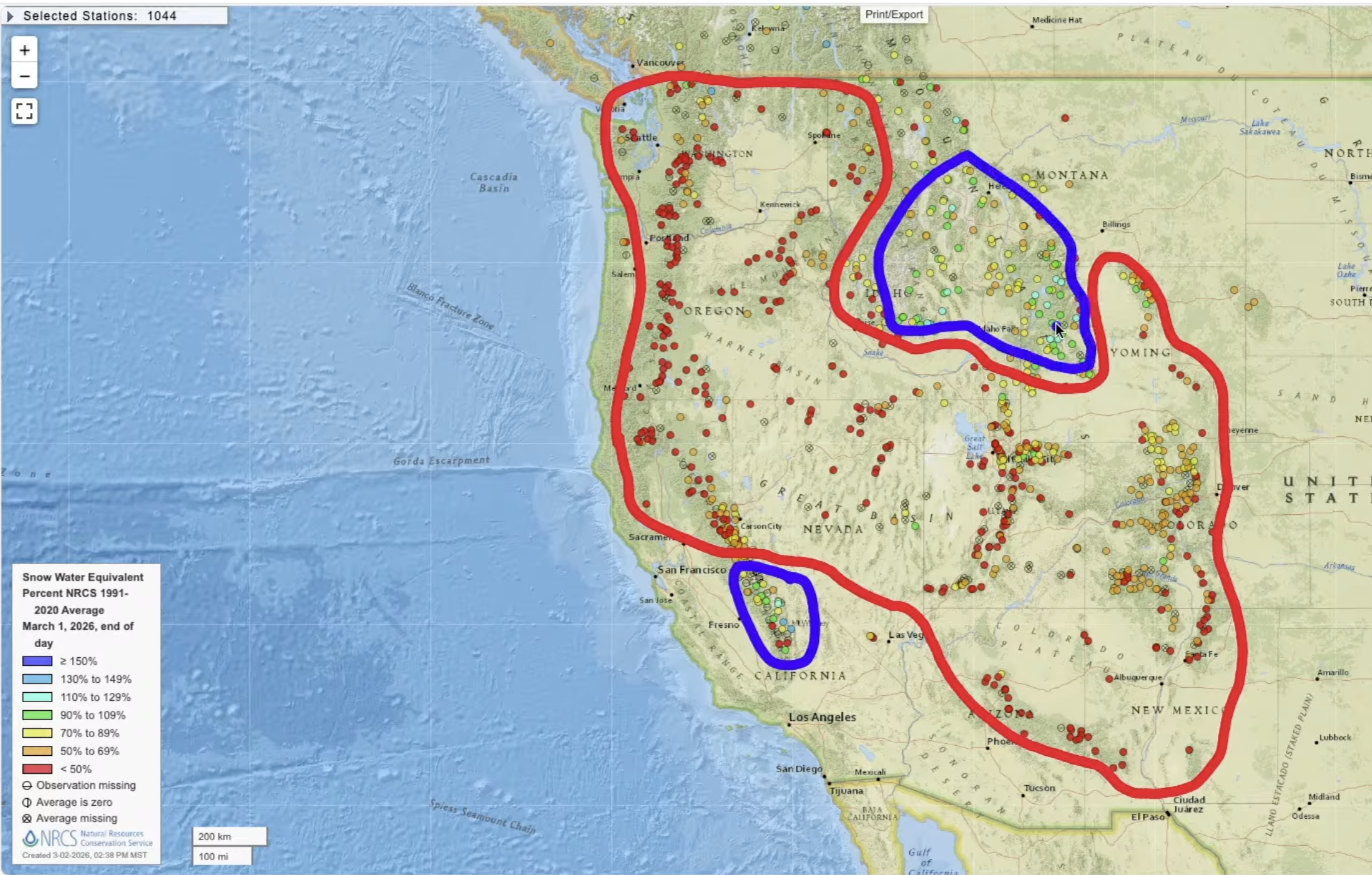
Now take a look at this Swain sketched map showing the few areas in the west that had normal or near normal snowpack outlined in blue including the southern Sierra, parts of Idaho, Wyoming, and Montana. The remainder of the West is suffering a snow drought, outlined in red.
There is of course, some good news for California water supply in that almost all the reservoirs in the state are enjoying above average storage for this time of year and some of them are full. California residents are seeing green fields and foothills across from the state and hopes this also means a low fire season ahead.
The Climate Prediction Center’s current forecast map says it all. Compare the contours on this March temp forecast map with the 3 month map at the lead to this story. The heat continues in the same locations.
‘one more note of interest from Dr. Swain he expects a strong El Niño to develop later this year that should impact next season’s rainfall likely more intense.