
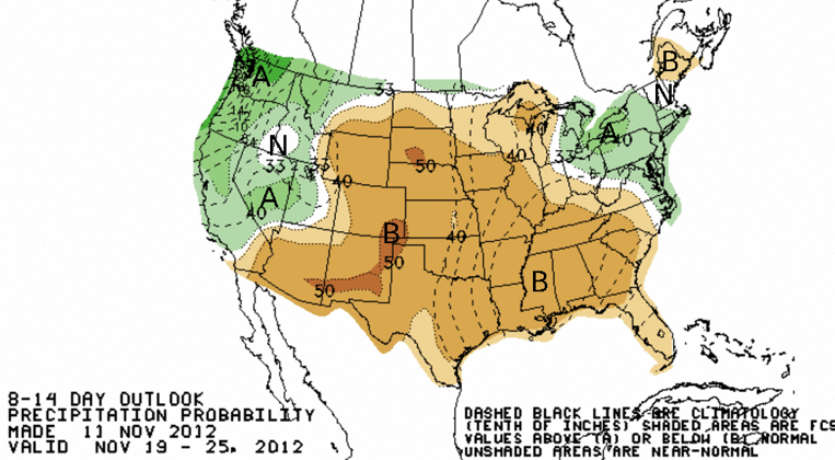
The winter storm door appears to have opened nearing mid-month in California with the 10 day forecast for Redding near Lake Shasta(the base of our hydraulic empire) showing likely rain for 7 of the 10 days coming up. Further south things are less optimistic with the best chances for rain coming next weekend (Nov 18/19).
On the Central Coast PG&E forecaster John Lindsey says today to expect some showers Thursday and Friday but that that “longer range charts and models are advertising a significant low-pressure system with increasing southerly winds and rain on Sunday into next Monday.”
NWS Hanford talks about the two systems as well saying snow levels in the Sierra on Thursday will remain at 8k ft with mountain areas receiving a quarter to half an inch of precip.
Some Ski Resorts Open
Several California ski resorts are already open and more expect to open in the next week, always good news this time of year.
Mammoth Mountain along Hwy 395 is open and Boreal in Tahoe is now operating as are Bear Mountain, Snow Summit and Mountain High resorts in southern California that opened today in honor of Veterans Day. Tahoe’s Squaw Valley and Northstar expect to open on the 16th.
In the Central Sierra a snowstorm turned Shaver Lake into a ‘winter wonderland’ this weekend. At nearby China Peak “We are into some real good snow making conditions right now so that’s going to help and hopefully some more storms in the horizon,” Paul Gray of China Peak Resort told the Fresno ABC station.
The China Peak website suggests a Thanksgiving opening is more likely.”10-12 inches of new snow this week, and very cold temps for snowmaking give optimism for an early opening! Unless we receive significant snow this week (week of 11/12) the only thing we might open on November 17-18 would be one of our beginner moving carpets, so we’d have something in the base area only for beginners and those who want to get started on their skiing or snowboarding life with our Learn-to-Ski & Ride packages!
If we don’t see lots of snow this coming week, but we get some snow and continued snowmaking opportunities we’ll look to hopefully open Chair 6, mid way up the mountain, serving one low intermediate run (Sundown Ridge) by Friday, November 23, so stay tuned!”
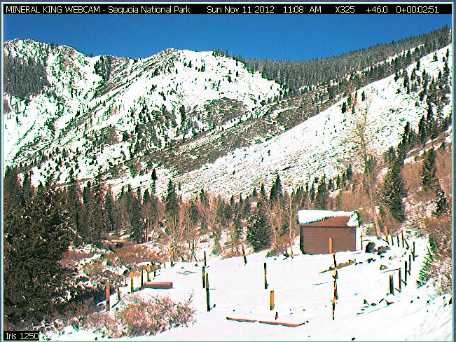
Further south our picture from this weekend snow shows a dusting of snow in Mineral King Valley from their webcam with Big Meadows cross country ski area getting 3.6 in of precip so far this water season and over 2 inches this month.Further south, Quaking Aspen has over 3 inches so far this season and received 0.40 inches on November 11 alone.
It’s a start to hopefully a better water year,not just for skiers but all water users.
Weak El Nino?
Forecasters have saying that chances for a wetter winter in California have been scaled back after an early EL Nino weather pattern call this summer boosted hopes coming from the NOAA”s Climate Prediction Center. “While the tropical ocean and atmosphere may resemble a weak El Niño at times, it is now considered less likely that a fully coupled El Niño will develop,” NOAA experts wrote in a Nov. 8 update. “Therefore, the previous El Niño Watch has been discontinued as the chance of El Niño has decreased. While the development of El Niño, or even La Niña, cannot be ruled out during the next few months, ENSO-neutral is now favored through the Northern Hemisphere winter 2012-13.”
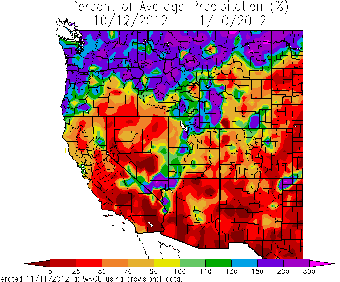
So far this season it is the Pacific Northwest that is seeing above average rainfall,an El Nino pattern.
Shrinking Snowpack?
Longer term,climate change is likely to alter the volume and timing of the runoff in California says new report released this week.
Stanford University researchers say climate change will shrink mountain snow pack but speed early runoff in more years according to their model,CMIP5.
“One clear result is that western North America shows the most rapid and largest response to the continued emissions of greenhouse gases when it comes to early snowmelt and spring runoff,”researcher Noah Diffenbaugh told the Chronicle this week.”The result, he and his colleagues say, will be less runoff water for irrigation during the season when California’s high-value crops need it most for growing, and also more early.”
The study concludes“We find that the CMIP5 global climate model ensemble exhibits an imminent shift towards low snow years in the Northern Hemisphere, with areas of western North America, northeastern Europe and the Greater Himalaya showing the strongest emergence during the near-term decades and at 2 °C global warming. The occurrence of extremely low snow years becomes widespread by the late twenty-first century, as do the occurrences of extremely high early-season snowmelt and runoff (implying increasing flood risk), and extremely low late-season snowmelt and runoff (implying increasing water stress). Our results suggest that many snow-dependent regions of the Northern Hemisphere are likely to experience increasing stress from low snow years within the next three decades, and from extreme changes in snow-dominated water resources if global warming exceeds 2 °C above the pre-industrial baseline.”
Guess you better save up that precious water and lower your footprint.