
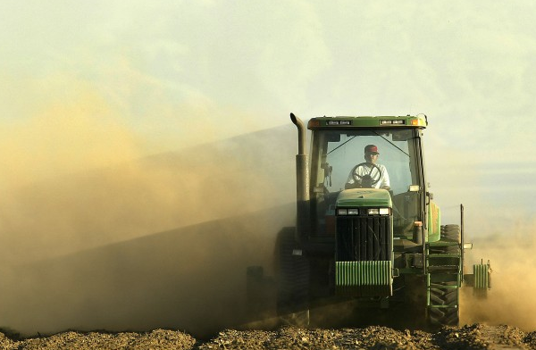
 There is a growing ripple effect on the San Joaquin River flow capacity due to vigorous groundwater pumping in one part of the Valley – in Madera County. The land below some farmers feet is sinking and sinking faster and the implications resonate far and wide.
Land adjacent and just east of the San Joaquin River between Dos Palos and Los Banos is sinking at an accelerated rate new state studies have found. So says Chris White,manager for Central Valley Irrigation District who told his findings to a meeting of Associated California Water Agencies (ACWA) in Fresno last week.
Survey work on the San Joaquin River as part of the Bureau of Reclamation restoration process in 2010 found land subsidence in this area of nearly 2ft compared to benchmark survey done in 2008.
White says a dramatic illustration of the drop came when a farmer last July texted him a photo of his well casing that had been painted a bright color down to ground level a few years earlier but now was unpainted a good 18 inches from the ground.”What’s going on here” asked the farmer?
It wasn’t gophers. More like an episode of ’Honey, I Sunk The Farm.’
“If this problem is left unchecked it is possible to see land subsidence of 28 feet or more.” Did he say 28 feet?
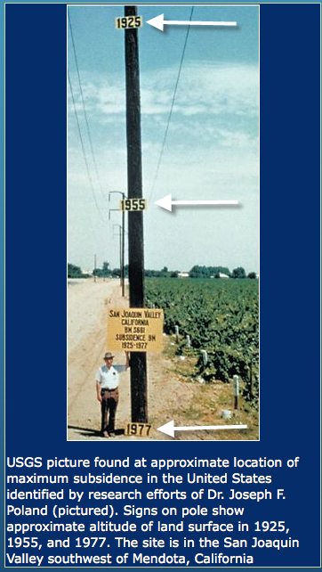
A famous photo shot near Mendota in 1977 shows just how much Valley farm land sunk from 1925 to 1977 which was about 28 ft according to a USGS study. More on this later.
The subsidence has been a long term problem in the area caused by over pumping of deep groundwater by farmers but the rate until recently had been slower. Identification of a rapid ground level decline in this specific area only dates to May of last year, says White, and adds up to as much as 5 ft over the past few years at at a rate of 1.25 ft a year.
“This land subsidence if left unchecked has serious impacts to public safety,flood conveyance and water supply” White told the AWCA meeting of fellow water agencies.
25% Decline In Channel Capacity
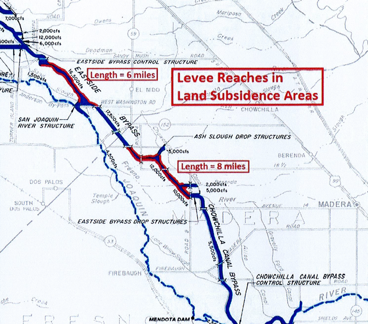
A recent analysis by the state DWR shows that “subsidence has caused about a 4000 cfs reduction in flood water conveyance or about 25% of capacity along the river’s important East Side Bypass. The parallel San Joaquin River flow capacity has also been reduced he says, although that flow reduction level is still under study. “It looks like the river channel is sinking about 6 inches a year but we don’t know how much that has cut its carrying capacity.” He says “we may know in a few weeks.”
The sinking land could spell all kinds of trouble. In the event of a flood flow the size the region experienced in 2006 – the river would overflow its bank says White, likely flooding Hwy 152,the City of Dos Palos, farmland nearby and an elementary school in the Red Top area.
Beyond flood issues,the sinking land has water supply implications for Valley water districts nearby and in other parts of the Valley.
White explains that the Bypass and the San Joaquin River depend on gravity flow to deliver water and if the subsidence continues at the current pace it would “ jeopardize about 55,000 acres in the San Luis Canal Co district and the Central California Irrigation District” that White heads up.The district serves some 1600 farms.
About 14 miles along the ByPass are affected.
Since these key channels can not pass some flood flows from both the San Joaquin River drainage and Kings River – the reservoirs that hold water back could face new management issues including Pine Flat,Friant Dam and Hidden and Buchanan Dams, in other words the water supply for much of the Valley.
Flood vulnerability in the Los Banos area would force the Corp of Engineers to require earlier and reduced water releases to avoid the flood potential.The upshot would be that all who depend on those waters would be at risk of reduced water supply since the SJR is the only outlet to the sea for the Central and South Valley.
The issue is a touchy in in the current drought climate when Valley farmers are giving up water for fish and because of the same drought -farms have literally pumped up ground water extraction to keep their plants alive.
It becomes a vicious circle.
“This problem could lead to finger pointing by a number of water users affected by the pumping of a few farmers” says Ron Jacobsma of Friant Water,who depend on SJR River water. A lower level in this area could lead to migration of groundwater from one area to another also raising water quality issues – salt water moving for example. Along the river landowners affected by failing levees could claim damage.
Seeking Solutions
White says a short term plan now underway will be to buy and deliver 10,000 acre ft of surface water and replenish the deep aquifer near Sack Dam where the worst of the subsidence is happening.”These farmers don’t currently have access to surface water for recharge.”
White says long term the plan will be to develop more conjunctive use water adding around 700 acres of recharge basins,developing a plan to divert flood water,developing a 10,000 acre ft annual supply of purchased water to continue the recharge effort and re-drilling deep wells as shallow wells to allow the recovery of water levels below the Corcoran Clay that hold up what has been termed the richest ag region in the world.
Besides problems in in this district – levees along the entire stretch of the San Joaquin as it heads to the Bay Area are at risk – almost 200 miles as the land sinks and those levees sink too – creating instability and leaks that turn to floods.
There is an issue for the Department of Reclamation as well planning the restoration of the San Joaquin River to accommodate salmon with plans to invest millions in infrastructure to do so. Sack Dam where the subsidence is worse is a focal point as the engineers look to design fish passage through sinking waterways.”What elevation should they design for” asks Friant’s Jacobsma.
White adds that the area where they are designing fish ladders for salmon returns for 3 decades of useful life – the rug is being pulled under the engineers who may now need to build the infrastructure as much as 15 ft higher.
Reduced capacity on the San Joaquin also could affect Friant’s ability to get restoration water flows recirculated that they are counting on long term in this water short valley.
28ft drop
DejaVue All Over
In a 1977 USGS report Dr Joe Poland wrote in an abstract:
Land subsidence which began in the mid-1920’s due to ground- water overdraft in the San Joaquin Valley has caused widespread concern for the past two decades. Withdrawals for irrigation increased from 3 million acre-feet in 1942 to 10 million acre-feet in 1966. Water levels declined at unprecedented rates during the 1950’s and early 1960’s.
Pumping lifts became inordinately high,well casings failed at alarming rates, and differential settlement caused numerous farming and engineering problems.
By 1970, 5,200 square miles of Valley land had been affected, and maximum subsidence exceeded 28 feet.( see pic)
The valley wide volume of subsidence totaled 15.6 million acre-feet one-half the initial storage capacity of Lake Mead. This subsidence represents one of the great environmental changes imposed by man.
The report adds that importation of surface water in the late 60s and early 70s through the Friant-Kern Canal and the California Aqueduct has meant pumping of ground water has been reduced, and the rapid decline of artesian head has been reversed in parts of the areas of overdraft.
A similar recharge effort of surface water in the Hwy 152 area could help stem the falloff says White, adding he is optimistic the cooperation of farmers to do recharge and limit pumping will make this happen.
Farmers in the rest of Valley hope he is right.