
-April 12,2022-
 No, the water year is not over as of April 12. Concern that no storms will come into
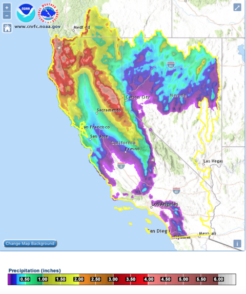
6 day forecast shows nearly 5 inches expected near Shasta
California this month (like January and February) leaving us in extreme drought may be overblown as a parade of moderately wet storms comes into northern California through the end of the month according to the GFS models.
This latest 6-day forecast for the 12-18th shows nearly 5 inches of precipitation could fall in the Shasta area -home of the state’s most important reservoir as well as Oroville.
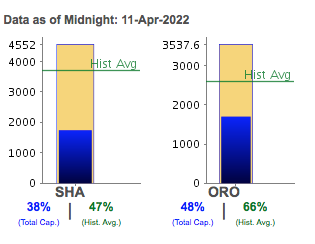
The water level at Shasta Dam is a key metric of whether water will flow south of the Delta this summer or not.
Shasta sits at just 38% of capacity now having received just 36 inches of precip this water year. In 2019 around this time, the reservoir had seen nearly 80 inches.
So adding an additional 5 inches in the next week will be welcome by both farmer and fish.Today there was a foot of new snow in the Tahoe area as the state switched from extreme heat to nice and cold.
After the 18th, there are apparently three more storm with moderate moisture that will dive into the state according to models.
Storms are dropping down from the north on the 19th, 22nd and 24th -with some reaching down to Central California and depositing snow in the southern Sierra. These are not sure things but at least there is some hope.
UPDATE: Series of incoming storms into N California fueled by Pacific typhoon. April 14 –West Pacific Typhoon #Malakas now appears likely to substantially perturb North Pacific jet stream as it recurves in coming days, possibly bringing a substantial (though much welcomed!) late-season rain event in Oregon and the northern 1/3 of California.