
-January 2,2022-
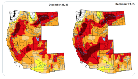 Cold storms over the past weeks have been impressive, raising hopes for a wet water year in California. A review of precipitation totals up and down the state shows Jan 1 rainfall since October 1, are already ahead of all last water-year. Snowfall is big this year too with Yosemite’s famous Tioga Pass recording just one foot on the ground December 13 and now 7 feet as of December 28. Statewide snowpack is 153% of average for the date and 49% of April 1 average. Sierra Snow Lab in Tahoe is reporting December’s total to 202.1″, which makes it the third snowiest month on record here (back to 1970). That is just under 17 feet with a few days of snow to fall.
Pictured: Drought Monitor shows less
In Northern California the precipitation index stands at 172% of average for Dec 28. That includes the state’s most important reservoir at Shasta Dam. The dam has a good way to go to fill to pre-drought levels, however.Today, storage reached 1.3 million af but the reservoir holds 4 million af. This time in 2020 it held 3.3 million af.
The San Joaquin Precipitation Index is at 169% of average for the date – runoff that will fill the Friant Kern Canal next spring.Tulare Basin average is 149% – on a track for the second wettest year ever. The latest precipitation number from Pine Flat dam shows around 9 inches to date, ahead of all last year when the dam got just 8 inches.
Also ahead of all last year’s precipitation are Giant Forest in fire- scared Sequoia with about 18 inches approaching New Year after seeing just 13 inches of rain all last year. Lake Shasta has received around 30 inches to date as of Jan 1 compared to 25 inches all last year. Call it another Santa Claus rally. The rally will continue at a lower volume with about another inch of precipitation in the southern Sierra between Dec 29 and Jan 2 says a forecast repor