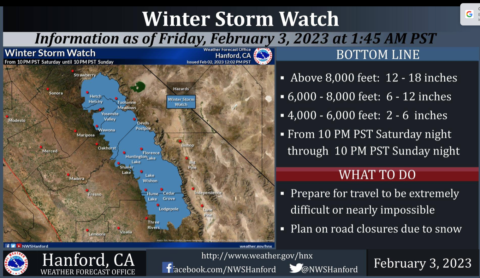
Look for an organized storm hitting Central California starting very late Saturday night bringing the region yet another atmospheric river reports the NWS in Hanford
Models place subtropical moisture surging toward California on Saturday and Sunday before diminishing on Monday. Therefore, will expect enhanced precipitation rates as models place good jet-streak dynamics over Central California which will in-phase with the plume of atmospheric river moisture
crossing the area.
Presently, models place the heaviest precipitation over Central California
on Sunday morning as orographic effects allow for values to reach over one inch of liquid water. Total precipitation values could reach 1.5 to 2
inches of liquid while the lower elevations will see a quarter to half of an inch of rain.
Ensembles are expecting a weak atmospheric river as lower precipitation values will be observed
across the valley with less than one inch being more common along with some rain shadowing also occurring over the west side of the
San Joaquin Valley. This will be due to the orientation of the southwesterly flow during the event.
Based on the precipitation totals, models place snow levels near the 6500 to 7000 feet at the start of the event. Yet, with the
frontal passage occurring early Sunday, will see snow level lower to near 4000 feet by Sunday afternoon. This will allow some lower
elevations to see snow while the higher terrain observed as much as two feet of new snow
Hopefully, the lower snow levels will limit the threat of more water on an already saturated ground.
 -February 3,2023-
 Look for an organized storm hitting Central California starting very late Saturday night bringing the region yet another atmospheric river reports the NWS in Hanford