More rain in March expected
-March 6 2023-
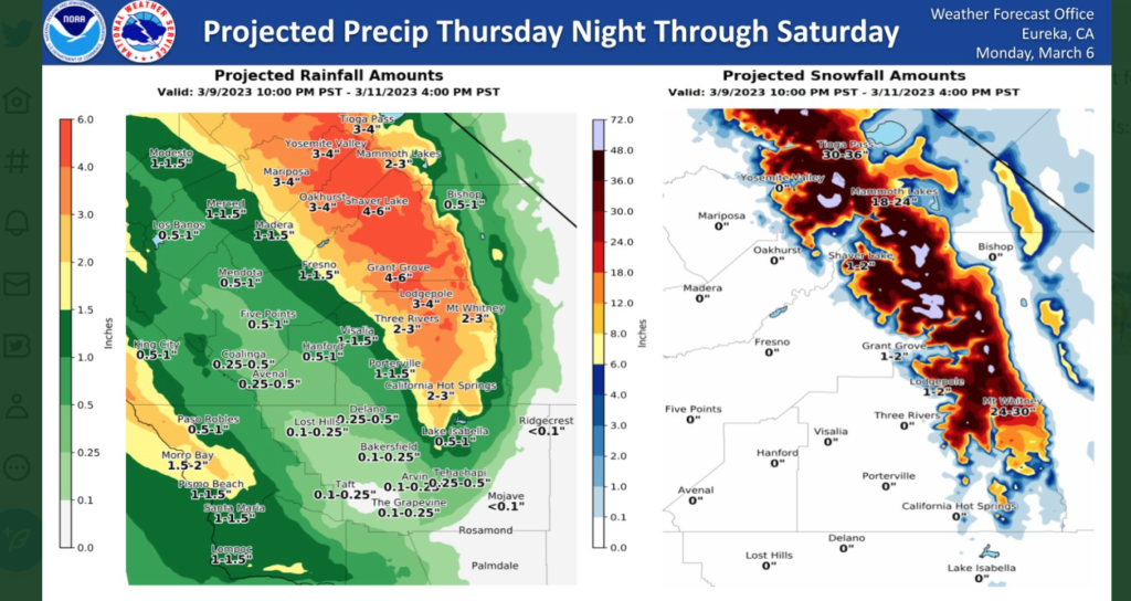
NWS Hanford is reporting that a much warmer storm system will impact Central California Thursday night through Saturday, resulting in rain in the Sierra Nevada foothills and Sierra Nevada below 8,000 feet. The majority of this precipitation will fall Friday and Friday night. Flooding is possible.
Parts of the The Central Coast could get an additional 2 inches of rain over the two day period.
Here is NWS’s discussion….
We will have a much welcomed break from precipitation Tuesday through Thursday of this week, which should be a few pleasant days for the valley. Temperatures will remain largely the same, with highs near the sixties and lows nearing the forties for the San Joaquin Valley through Friday. Temperatures in the valley will warm over the weekend, with highs in the mid to high sixties and lows nearing 50 degrees. A strong storm system in the Pacific Ocean will approach the California coast and begin impacting our area Thursday night through Saturday. This atmospheric river will bring an abundance of subtropical moisture into the area alongside widespread precipitation. This warmer moisture will cause snow levels to be extremely high, beginning at 5000 feet and above on Thursday and rising to 8000 feet by Friday. These high snow levels combined with moderate to high rain totals will result in rapid snow melt in areas that have received several feet of snow in the past few weeks. Rain totals for the area are: half an inch to an inch of rain for the central valley, one to one and a half inches of rain for the eastern San Joaquin Valley, and 2-3 inches and above for the Sierra and foothills, with some high totals of 4-6 inches at Shaver Lake and Grant Grove. Because of very high snow levels, snow totals will be high for only a few locations: Tioga Pass, Mammoth Lakes, and Mt. Whitney could each see one to three feet of snow. Other areas will see very low snow totals of 1-2 inches, while the rest of the precipitation that falls will be rain. Much of the precipitation is forecast to fall Friday and Friday night. This combination of heavy rainfall and rapid snow melt could prove to be very problematic and result in dangerous flooding conditions. Water levels will rise in river areas and streams Thursday through Saturday. People living near rivers and streams should closely monitor water levels and be ready to move to higher ground if the threat of flooding becomes imminent. People in these areas should also have an evacuation plan and keep a close eye on our websites and social media for further hydrologic updates. Our office has issued a Hydrologic Outlook with more information due to the threat of flooding for these areas.
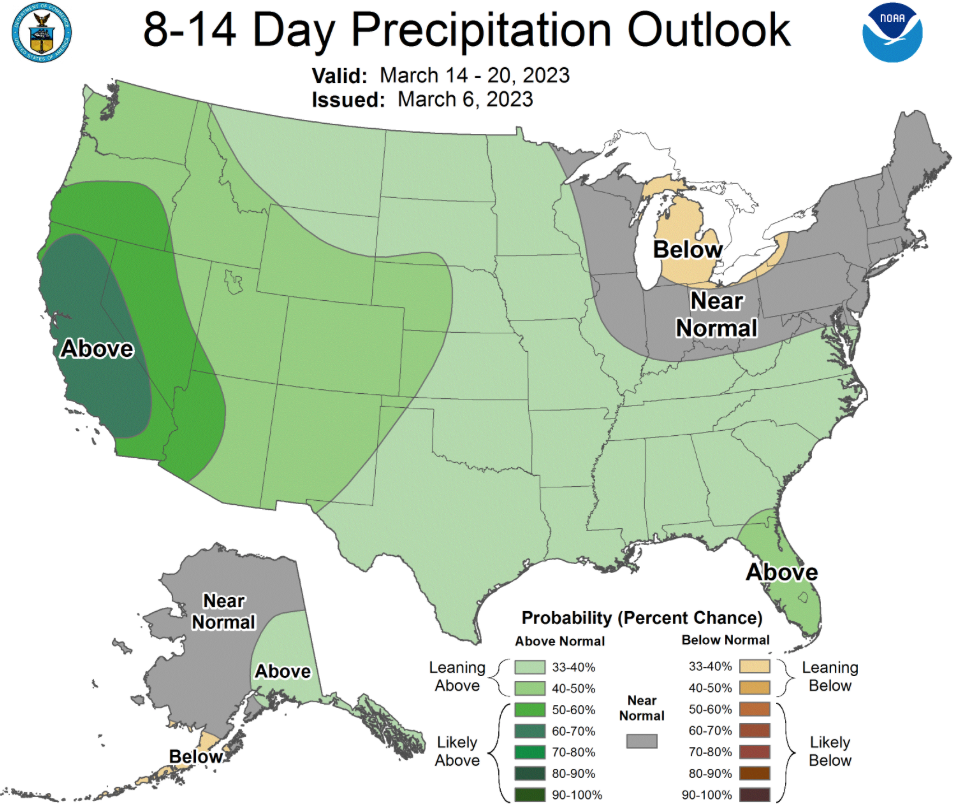
Also below: Climate Prediction Center expects more rain in the next two weeks