
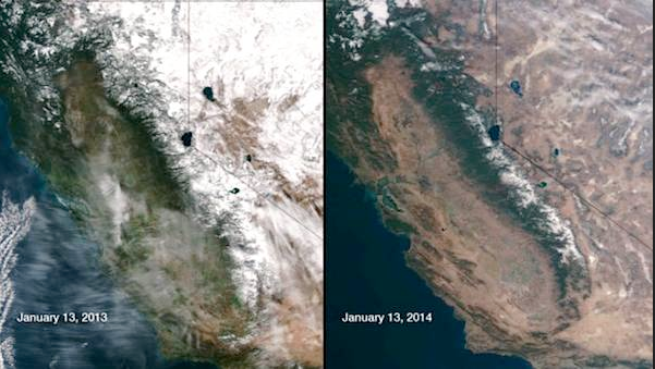
Forecasters are for the first time this year suggesting the persistent high pressure ridge that is keeping storms away from the state will dissipate as we head into February.
Lack of rain or snow this winter has crated a parched landscape across the Golden State that is rapidly turning an ugly gray. Here is how the drought looks from space on the same date this January and January a year ago (see photos).
But today here is what PG&E forecaster John Lindsey wrote. “The stubborn ridge of high pressure that has produced the drought is expected to move away from the West Coast and allow a more normal winter type of pattern to develop i early February. This condition could bring much needed precipitation to California.”
Weatherman Alan Fox, who advises avocado growers, says he expects some rain although from “ February 1 to 13 – The current pattern of sea surface temperature anomalies in the east and central north Pacific does not support a return to above normal rainfall. Although El Niño influence is expected to slowly increase, the current overall pattern still makes it difficult to realize a return to normal rainfall until after the typical end of the wet season.”
Some Storms
“February 1 to 13 – Southern California Avocado Region… On the whole, rainfall will continue to be below normal, but there should be some good storm events to increase the surface moisture a bit. February 8 to 15 has historically been an active time for rain in southern California.
Fox continues – “Seasonal Outlook/El Niño Update – February 15 to April 30… The El Niño will start to increase in February, March, and April. February could become more rainy, especially in central and southern California.”
Snow Forecaster Bryan Allegretto who comments for the ski industry watches different weather models says “No changes today as the models are still showing the mean ridge moving away from the West Coast and out towards the Aleutians by the end of the month. Looking through all the ensemble runs of the European, Canadian, and GFS they all have the trough spending more time along the West Coast than not to start the month of February.
The operational runs of the GFS and European have a system pushing in next Friday. Beyond that we’ll just look at the pattern vs. any storms. “
Wet February?
He adds “Taking a look at today’s CFS v2 runs for February they show 200% of average precip for February. They have been trending wetter. I’m not foolish enough to buy into that after the season we are having, but it’s another sign that the models are seeing good signals for the West Coast as we go into February. They have been showing a West Coast trough setting up at the end of the month for a week now so that’s good consistency.”
But NWS-SF remarks in their discussion” that models show the very real possibility there will no more rain this month.”
If that is the case worried Californians will be glad to say goodby to January.