
UPDATES
John Lindsey:12/14/23 says
“I hope the models for Wednesday, December 20, don’t verify. They indicate storm-force (50+ mph) southerly winds and up to three inches of rain in less than 24 hours. Altogether, from this Sunday evening through the end of the year, up to 7 inches of rain could be recorded in many Central Coast locations, with higher amounts in the Santa Lucia”
Other forecasts suggest Latest GFS model as Dec 14 show central California could see rain for 10 days through December 29 with a couple of days break for Christmas!
China Peak ski resort above Fresno is expecting snow starting December 17-18, The lifts will open Saturday, December 16-18, then daily December 21 through January 1, then to our five day per week schedule through April.
-December 10,2023-
Local weather forecaster John Lindsey is adding his voice to predictions of a a wet patten pattern visiting the central coast after December UCLA forecaster Daniel Swain posted the same prognostication this week as well on the website Weather West.
Here is John Lindsey’s post
“Rea Strange, my mentor, and legendary meteorologist, emphasized, “Pay close attention to the mid-latitude westerlies; when they extend across the Pacific, there’s a high likelihood of significant precipitation.” Recent runs from the numerical models suggest the possibility of heavy rain and higher-level snow setting in from Dec. 19, possibly persisting into January 2024, pending the validation of these models. On Christmas Day, an aircraft departing from Japan en route to the United States would surpass the speed of sound in actual ground speed. If your roof is prone to leaks, I strongly advise addressing repairs within the upcoming week. The GFS indicates between 2 and 5 inches of rain for much of the Central Coast between Dec. 19 and Christmas.”
And from Daniel Swain.
After frustrating false starts, strong indications of a major Pacific jet extension & active pattern by late Dec
Fresh off the presses (the 12z GFS ensemble average from 12/8), it depicts a dramatic eastward extension of the jet stream beginning within a week near the coast of Japan and then eventually extending across almost the entire North Pacific basin toward the California coast (over 5,000 miles away!) by about 2 weeks from now.Here isa rendering of the pattern
Swain predicts “A relatively dry and warm pattern will continue for the next 7-10 days, then with perhaps gradually more active conditions 10-14 days from now before potentially more dramatic shift toward wet and active conditions after that–most likely sometime during the last week in Dec. But this Pacific-wide rearrangement of the longwave pattern is exactly what we would need to finally break down this wavy jet and mostly “ridgey” pattern that’s stuck around the past couple of months.”
Is there 100% certainty in this pattern change? Well, the odds of a remarkably strong zonal jet over the Pacific do appear very high at the moment. But the critical time for California remains about 2 weeks out, then the nose of this powerful jet core would possibly arrive near the coast. Will it make it all the way, and will it still be remarkably strong? Will it direct a sequence of strong/moist storms into California in the days following? I’m leaning toward yes at the moment, but as always…things can change, and this is still a fair distance in the future. Uncertainty is high, but this certainly has potential. So: stay tuned! I’ll be updating on various social media sites (including YouTube office hours) in the meantime; if something really big does end up developing, that’ll be the trigger for the next blog post 10-14 days down the line.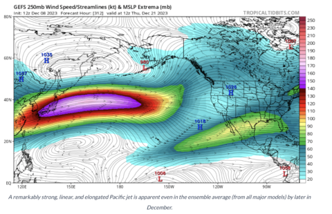
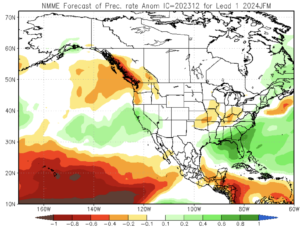
Wet and warm
The newest slew of seasonal model predictions for the core winter months–January through March–we just released a couple of days ago. And the theme is very familiar: they continue to point, as they have for months, toward a pretty decent tilt in the odds toward wetter than average conditions in California (especially central and southern CA) during this period. (Notably, they did not do so for the Oct-Dec period.) They also point toward very high confidence in a warmer than average winter across nearly the entire Western U.S., including California. So it would not be tremendously surprising to see above average precipitation but near to below average snowpack in some portions of the Pacific Southwest this year due to this persistent warmth. Elevation will help mitigate that–near and along the mountain range crests, there’s a pretty good shot of hefty accumulations this year–but lower down the slopes, the strong El Nino event plus the long term warming trend might mean that temperatures will be a problem for snow lovers at lower to middle elevations this season.