
-February 28,2019-
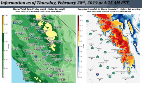
 A fab’ February looks to turn into a momentous March with several atmospheric river storm events heading our way in March.
Snowpack continues to pile up and Central Sierra’s San Joaquin precip index stands at 127% of average today – good news for all of us who depend on runoff to fill the reservoirs.
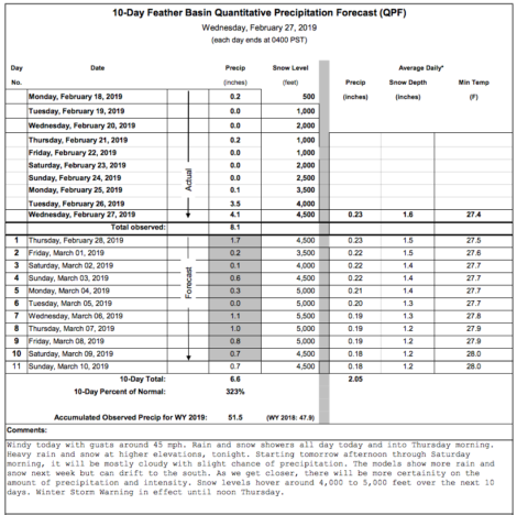
In northern California the Feather River forecast is 323% of average for the next 10 days.
The Snow Show
UPDATE: Several ski resorts including Sugar Bowl and Squaw claim this as the snowiest month ever recorded.
February still has a few days to go but here are a few eye openers.
Tioga Pass entrance station in Yosemite has reached 170 inches in snow depth as of late February , around 14 feet, but still short of the 2016/2017 snow depth of 216 inches, or 18 feet. At the beginning of February 2019 – it had just 5.5ft piled up.
Two years ago, the 2016/ 2017 ski season gave Tahoe ski resort Squaw Valley a record-breaking snowfall total. They called it SNOWMAGEDDON, Janu-BURIED, Febru-BURIED and other quips. Squaw Valley stayed open past 4th of July for the first time in their history.
The winter 2016-17 remains the wettest on record in the Northern Sierra. The season total for that snow year, 728 inches.
Near Lake Tahoe, Squaw Valley has picked up a total of 300 inches of snow – 25 feet in February 2019- and 557 inches for the season to date. More is on tap in the next few days.
Mammoth Mountain has received a whopping 198 inches of snow through Feb. 26, which is the highest total for the area since the records begin in 1970.
China Peak above Fresno records 342 in of snow so far this season on the upper mountain.