
Reports from Daniel Swain and the Center for Western Weather and Water Extremes offer a glimpse of what to expect in the few weeks.
 Model ensembles have backed off substantially on expected precipitation across CA during rest of November. Widespread soaking & likely fire-season ending rain is still likely across northern 1/3 of state, but totals closer to Bay Area will be lower & SoCal will remain dry.
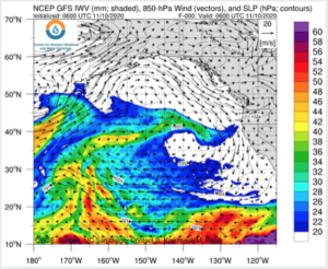
An active pattern is forecast to bring multiple landfalling atmospheric rivers to the Pacific Northwest and Northern California
•The first AR is forecast to make landfall on 13 November, though there is currently large ensemble uncertainty in onset and overall duration of AR conditions
•The second AR is forecast to make landfall over the Pacific Northwest on 15 November but is also associated with large ensemble and model-to-model uncertainty
•The GEFS control member is currently suggesting that first AR could bring AR 2 conditions to Northern CA and Southern OR while the second AR could bring AR 4 conditions to Southern OR
•The NOAA Weather Prediction Center is currently forecasting >10 inches of precipitation over the high elevations of the Coastal, Olympic, and Cascade Mountain Ranges during the next 7 days.